In the mid ’60s, they determined that the island’s width blocked river traffic, thanks to the “pier” placement for the new Hernando de Soto Bridge (that many still call the “new bridge”), which opened in the early ’70s and carries I-40 across the island and the river.
So with the full intensity of terra-forming titans, the Corps dug up half the island, moving north to south, and created a more slender, horizontal form. At the same time, needing a place to dump the mud, the Corps placed it on top of the remaining island, effectively raising the island’s height so it permanently sat above flood stage.
The outcome was a big ol’ pile of mud — albeit one that did not impede river traffic and better prevented flooding. The aesthetics of the pile of mud were then left to the City of Memphis.
In the early ’70s, the city made the breakthrough decision to develop the island in an effort to continue its battle to rebuild a Downtown devastated by the aftermath of Dr. Martin Luther King Jr.’s assassination in 1968.
It was obviously a big task, and it needed a designer and architect with demonstrated ability to change a progressive vision into reality. There were a number of choices, of course, as the project intrigued designers worldwide. But the best choice had to be Roy Harrover, a Yale graduate and Nashville native. His resume was already impressive, including Memphis landmarks such as today’s Memphis College of Art and the Memphis International Airport — internationally acclaimed for its forward-looking “airport in the air” design.
A look at the plans that Harrover showed the Memphis mayor and city council proved they had made the right hire. First, there was his vision. “Mud Island is a unique land area with unparalleled views westward across the Mississippi, of the green fields and woods of Arkansas, and eastward, across the 250-foot Wolf River channel, of the dramatic skyline of Downtown Memphis,” he wrote in 1976, clearly understanding the island’s importance and potential.
And there were his suggestions. “The first plan was perfectly obvious,” Harrover remembers today from his Midtown home. “Fill up the Wolf River, turning the whole thing into an open, green, formal, city park — then turn it over to the public.” But that required a lot of dirt (even more than had already been displaced), and it would cover the cobblestones on the riverfront — an option Harrover loathed.
“The second idea I had was the Ponte Vecchio,” Harrover says, referencing the famous medieval bridge spanning the Arno River in Florence, Italy, renowned today as home to a varied collection of shops, art merchants, and retailers that make it an integral part of the city.
The third choice, then, was the current structure, which Harrover conceived as a sort of fort overlooking the river — a structure more impervious to flooding, but still connected to the river. More, the island would house a museum that detailed the history of the river, as well as a monorail system — which is still unusual to this day because the train hangs from the track rather than runs on it.
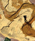
And then there was that other major feature: a scaled replica of the entire Mississippi River, complete with accurate, sloping ground levels, 20 comprehensive city maps of communities located along the river, and, representing the Gulf of Mexico, an acre-sized pool that held 1.3 million gallons of water.
“I don’t know how I got the idea,” Harrover says of the River Walk, as it soon became known. “But I did, and I thought of it even at that early stage. I first created a scale drawing of the river and superimposed the paper over the park plot. I saw it could be done and that it fit, but it wouldn’t be as big as we wanted to make it. So we decided to eliminate the northern portion of the river and its tributaries. The park’s north courtyard contains several vertical concrete wall maps that represent states and rivers that contribute to the upper Mississippi River. These include the Cumberland, Tennessee, Ohio, upper Mississippi, and Missouri rivers. By the time we were through with those drawings, we decided we could make the Gulf of Mexico a swimming pool, and it would fit and be a lot of fun.”
It’s important to appreciate the engineering feats the River Walk represents. “We knew we had to make it out of precast concrete, and we wanted to indicate the fall of the river,” Harrover continues. “In other words, our model had to slope down proportionately to the real river. We also knew we had to try to indicate the topography of the ground all the way. We had to ‘cheat’ a little bit with the grades so that we could keep a more even slope. It was an incredible challenge.”
That challenge included Harrover painstakingly including every twist and turn of the river, measuring and showing the respective depths. And, again drawing from the expertise of the same group who first turned the island into a pile of mud, Harrover relied heavily on the Army Corps of Engineers and their topographical maps. “The Corps of Engineers has the most beautiful maps,” says Harrover. “Not just of the river itself, but also a significant amount of real estate on both sides.”
One contour ridge in the riverbanks equals five feet of actual height, and its buff-colored concrete represents the floodplain, which includes all the sandbars, meanders, chutes, and oxbow lakes that surround the river’s main channel. The model is run at three levels daily, but does not correspond to the actual river stage. The water is re-circulated every 12 hours through nearly two miles of underground piping.
In total, the River Walk — five city blocks long — represents 954 scale miles, stretching from the river’s confluence with the Ohio River at Cairo, IL. “It turned out that the thing worked out at the scale of about one step to the mile — somewhere between 29 and 30 inches per mile,” Harrover says, obviously and rightfully pleased. “It’s wonderful. Actually, it was difficult, but everything fell into place. It really did.”
Mud Island River Park, 125 N. Front, 576-7241, mudisland.com.
|